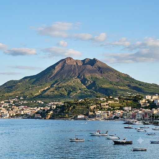
The Geological and Magmatic Architecture of the Somma-Vesuvius Complex
Introduction
Mount Vesuvius is a composite stratovolcano located within the Campanian Volcanic Arc on the western coast of Italy. Geographically distinct from the highly active island volcanoes of the Mediterranean (such as Etna and Stromboli) and the neighboring caldera depressions of the Campi Flegrei, Vesuvius represents the only active, edifice-building stratovolcano situated directly on the contiguous European mainland. The current cone, the Gran Cono, grew within the caldera of the older Mount Somma, a structural predecessor that underwent sequential collapse following the Pomici di Base eruption approximately 22,000 years ago.
Tectonic and Geological Setting
The volcanism of the Campanian Volcanic Arc is driven by the complex geodynamics of the convergent boundary between the African and Eurasian tectonic plates. The subduction of the Ionian oceanic slab beneath the Eurasian plate—coupled with subsequent slab rollback and the formation of a localized "slab window"—facilitates significant mantle upwelling.
As the subducting slab descends, it dehydrates, releasing fluids that metasomatize the overlying mantle wedge. This process significantly lowers the melting point of the mantle, generating primary magmas that are highly enriched in potassium and incompatible trace elements. During their ascent through the continental crust, these magmas undergo extensive fractional crystallization and crustal assimilation, ultimately producing the volatile-rich, silica-undersaturated rocks (shoshonites, tephrites, and phonolites) responsible for the volcano's explosive potential.
Magmatic Plumbing System
Extensive geophysical investigations—including high-resolution seismic tomography—and petrological analysis of fluid and melt inclusions reveal that Vesuvius is fed by a highly stratified, multi-level magmatic plumbing system. Magma storage and evolution occur across three distinct depth intervals:
- Deep Magma Reservoir (12 to 17.5 km depth): This deep zone serves as the primary accumulation area for primitive mafic magmas ascending from the mantle wedge. Its upper boundary is detected at approximately 12 km depth. Petrological data indicates an extensive stagnation and initial crystallization zone between 13 km and 16 km. The absolute bottom boundary of this reservoir is demarcated by the Moho discontinuity (the crust-mantle boundary) at a depth of 15 to 17.5 km. Ascending melts pond against this density barrier, forming a complex lower-crustal "crystal mush" of sills and dykes before migrating upward.
- Intermediate Magma Chamber (8 to 10 km depth): Seismic tomography has identified a widespread low-velocity anomaly spanning 8 to 10 km below sea level, interpreted as an extended, partially crystallized sill-like magma body. This mid-crustal discontinuity acts as a secondary staging area where ascending magmas stagnate, cool, and assimilate surrounding Mesozoic carbonate rocks.
- Shallow Magma Chamber (3 to 5 km depth): The most catastrophic eruptions in the complex's history are linked to a localized, highly evolved reservoir located 3 to 5 km beneath the surface. Prolonged residence time at this depth allows for extreme crystal-liquid fractionation, driving the residual magma to highly viscous phonolitic compositions. The subsequent exsolution and accumulation of volatiles create critical overpressures, culminating in highly explosive Plinian events.
Eruptive History and Dynamics
The eruptive behavior of Somma-Vesuvius over the last 19,000 years is characterized by cycles of extended quiescence punctuated by explosive events. The eruptive style is heavily dictated by which depth of the stratified magmatic system is tapped:
- Plinian Eruptions (High Magnitude): Events such as the Avellino eruption (~3500 BP) and the Pompeii eruption (79 AD) originated from the shallowest reservoir (3–5 km). These paroxysms involve the rapid decompression of volatile-saturated, highly viscous magma. They produce immense eruption columns reaching up to 30 km in altitude and generate devastating pyroclastic density currents upon column collapse.
- Sub-Plinian Eruptions (Medium Magnitude): Eruptions such as those in 472 AD and 1631 AD tapped heavily into the intermediate reservoir (8–10 km). While lacking the volume of Plinian paroxysms, these events are highly explosive, yielding widespread ash fallout and lethal pyroclastic surges.
- Effusive and Mixed Activity (Low Magnitude): Following the 1631 eruption, Vesuvius entered a prolonged period of semi-persistent, open-conduit activity. This phase was defined by Strombolian explosions and effusive lava flows fed primarily by magma originating from the deep reservoir (>12 km), which bypassed extensive shallow stagnation. This cycle terminated with the 1944 eruption, which sealed the main conduit.
Conclusion
Since 1944, Vesuvius has remained in a state of closed-conduit quiescence, exhibiting low-level volcano-tectonic seismicity and intracrater fumarolic degassing. Current geophysical monitoring indicates no substantial accumulation of molten material within the shallowest (3–5 km) zone. However, the intermediate sill at 8–10 km and the deep crustal reservoir extending down to the Moho (17.5 km) remain integral components of the active magmatic system. Given the dense population of the Campanian Plain, continuous monitoring of crustal deformation, seismic velocity anomalies, and gas geochemistry is critical for detecting deep magma ascent and forecasting future eruptive hazards.