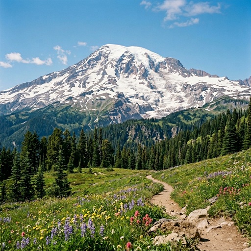
The Geological Architecture and Magmatic Plumbing of Mount Rainier
Mount Rainier is an active stratovolcano situated within the Cascade Volcanic Arc of Washington State. Rising to an elevation of 4,392 meters, it represents the highest peak in the Cascade Range. Beyond its topographic prominence, Mount Rainier is a complex geological structure shaped by active tectonic subduction, extensive glaciation, and episodic volcanism. Understanding its underlying magmatic plumbing system is critical for volcanic hazard assessment in the Pacific Northwest.
Tectonic Setting and Geological Evolution
The genesis of Mount Rainier is inextricably linked to the Cascadia Subduction Zone. This convergent plate boundary forces the dense oceanic Juan de Fuca Plate beneath the more buoyant continental North American Plate. As the oceanic plate descends, increasing temperatures and pressures initiate the release of volatiles, primarily water. These volatiles lower the melting point of the overlying mantle wedge, generating mafic magmas that ascend through the crust.
The geological history of the Mount Rainier region predates the current volcanic edifice:
- Tatoosh Granodiorite (18 to 14 million years ago): The foundational basement rock beneath the volcano is an exposed pluton resulting from an ancient, cooled magma chamber.
- Edifice Construction: The modern stratovolcano began forming approximately 500,000 years ago. Roughly 90% of the volcano's volume consists of lava flows, with the remaining 10% comprising pyroclastic deposits and mudflow breccias.
- Composition: The eruptive products are dominantly andesitic, containing approximately 61% to 62% silicon dioxide. This intermediate composition yields a moderate viscosity, allowing for both the effusion of thick lava flows and periodic explosive activity.
Magmatic Plumbing System and Vertical Boundaries
Recent advancements in geophysical imaging—specifically the integration of seismic tomography with magnetotelluric measurements—have provided a high-resolution model of Mount Rainier's deep magmatic plumbing system. Magnetotelluric imaging maps subsurface electrical conductivity, a metric highly sensitive to the presence of partial melt and hydrothermal fluids.
The vertical architecture of the magmatic system is delineated into distinct structural zones:
- Zone of Partial Melting: Initial melt generation occurs at a depth of approximately 80 kilometers, directly above the subducting oceanic slab.
- Lower Crustal Ascent: Magma ascends through the mantle wedge and crosses the crust-mantle boundary (Moho) at a depth of roughly 40 kilometers.
- Primary Crustal Magma Reservoir: The main storage zone is located in the upper-to-mid crust. Geophysical data indicates that the upper vertical boundary (the top) of this partially molten reservoir is situated roughly 8 kilometers beneath the surface. The chamber extends vertically for 8 to 16 kilometers, placing its lower vertical boundary at approximately 16 to 24 kilometers in depth.
- Spatial Offset: Notably, the primary volume of this crustal reservoir does not reside directly beneath the summit. It forms a lobe extending 10 to 16 kilometers to the northwest. This reservoir is estimated to be roughly 30% molten, behaving as a crystalline mush rather than a purely liquid cavern.
Hydrothermal Alteration and Lahar Hazards
While magmatic eruptions pose a significant threat—the most recent documented magmatic event occurring approximately 1,000 years ago—the primary geological hazard associated with Mount Rainier is the generation of lahars, or volcanic mudflows.
The interaction between the magmatic system and the volcano's extensive glacial ice cover drives a vigorous hydrothermal system. Upwelling magmatic gases, particularly hydrogen sulfide and sulfur dioxide, dissolve into heated meteoric water to form weak sulfuric acid. This acidic fluid continuously permeates the internal structure of the edifice, altering hard, crystalline andesite into structurally weak, clay-rich rock.
- Edifice Instability: Pervasive hydrothermal alteration fundamentally compromises the mechanical integrity of the upper volcano.
- The Osceola Mudflow: Approximately 5,600 years ago, a massive sector collapse triggered the Osceola Mudflow. This catastrophic event mobilized an estimated 4 cubic kilometers of hydrothermally weakened rock and ice, flowing rapidly into the Puget Sound lowland.
Conclusion
Mount Rainier is a dynamic geological system defined by an active subduction-driven magmatic feed and significant edifice degradation. High-resolution imaging of its 8-to-24-kilometer-deep magma reservoir provides a crucial baseline for interpreting seismic unrest and ground deformation. Because of its massive ice mantle, extensive hydrothermal alteration, and proximity to densely populated regions, Mount Rainier remains one of the most closely monitored volcanoes in North America.