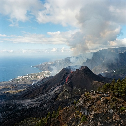
Geological Dynamics and Magma Plumbing Architecture of the Cumbre Vieja Volcanic Ridge
Geodynamic Context and Stratigraphic History
The island of La Palma, positioned in the northwestern sector of the Canary Islands archipelago, represents one of the most active volcanic systems in the Atlantic intraplate setting. With an estimated subaerial geological age of 1.7 million years, the island rests upon a Pliocene submarine foundation dating back approximately 4.0 million years. Historically, the island's locus of volcanic activity has migrated southward.
For the past 125,000 years, active volcanism has been exclusively restricted to the Cumbre Vieja, a 20-kilometer-long, North-South-trending rift zone (locally termed a 'dorsal'). Covering a surface area of 220 km², the ridge rises to 1,950 meters above sea level and continues offshore as a submarine ridge for an additional 20 kilometers. Eruptions along Cumbre Vieja are predominantly characterized by silica-undersaturated basanites and alkali basalts, exhibiting a combination of effusive and Strombolian explosive phases.
Statistically, Cumbre Vieja is the most active volcanic structure in the Canary Islands, accounting for eight documented eruptions since the 15th century: 1470, 1585, 1646, 1677, 1712, 1949, 1971 (Teneguía), and the 2021 Tajogaite eruption.
Magma Plumbing Architecture: Chambers and Vertical Boundaries
Recent geophysical investigations—including repeated seismic tomography, local gravity field modeling, and fluid inclusion barometry derived from the 2021 eruption—have provided high-resolution constraints on the trans-crustal magma plumbing system of Cumbre Vieja. Rather than a singular, continuous reservoir of molten rock, the magmatic architecture consists of a stratified, multi-tiered system of interconnected chambers and structural boundaries.
The vertical structure of the system is delineated into three primary domains:
- Deep Mantle Storage Zone (15 to 27 km depth): Primary melt generation occurs in the upper mantle at depths of approximately 25 to 30 km. Fluid inclusion barometry (yielding CO₂ densities ranging from 0.73 to 0.98 g/cm³) indicates that the primary pre-eruptive magma storage reservoir resides well below the Mohorovičić discontinuity (Moho), which is located at approximately 14 km depth beneath the island. This deep chamber spans vertical boundaries from 15 km down to 27 km, with the maximum volume of magma stagnation centered at approximately 21 km depth.
- Intermediate Crustal Stagnation and Rigid Barrier (5 to 11 km depth): As magma ascends from the mantle, it encounters structural and lithological traps within the oceanic crust. Seismic velocity anomalies (Vp/Vs models) reveal a distinct, rigid crustal barrier located between 5 and 8 km depth. Magma rising from the deep mantle storage tends to pool beneath this barrier, forming a secondary storage zone or stable diapir-like head at vertical boundaries of roughly 9 to 11 km.
- Shallow Ephemeral Sub-Volcanic System (0 to 4 km depth): Above the 5–8 km rigid barrier lies a shallow, fluid-saturated crustal region characterized by low-density rocks and active hydrothermal systems. Magma does not typically reside here for extended petrological evolution. Instead, during acute eruptive crises, ascending magma breaches the rigid barrier and forms highly pressurized, ephemeral sills at vertical depths of 3 to 4 km. From this shallow staging area, magma exploits pre-existing NW-SE-trending fractures to reach the surface.
Geophysical Dynamics of the 2021 Eruption
The 2021 basaltic fissure eruption provided an unprecedented empirical test for structural models of Cumbre Vieja’s subsurface geology. The eruption was preceded by a four-year period of deep, low-magnitude seismic swarms (15–35 km), reflecting the gradual volumetric recharge of the deep mantle storage zone.
Approximately nine months prior to the eruption, GNSS sensors detected a reversal in ground deformation—from localized subsidence to active uplift. This uplift correlated with the upward migration of magma from the deep chamber (15–25 km) into the intermediate stagnation zone (~5 km).
In the days immediately preceding the September 19, 2021 outbreak, rapid magma ascent was tracked via rapidly shallowing seismic hypocenters. The magma bypassed intermediate barriers, forming a transient sill at approximately 4 km depth beneath the western flank. Driven by extreme exsolved gas pressure (chiefly water vapor and carbon dioxide), the magma fractured the overlying shallow crust. This facilitated the rapid transport of an estimated 6 million cubic meters of magma to the surface within a 24-hour window, initiating an eruptive phase that persisted for 85 days.
Summary
Cumbre Vieja remains a highly dynamic geological system governed by a deep, trans-crustal magmatic feeding network. Modern petrological and geophysical data have successfully defined its vertical boundaries, highlighting a primary deep mantle reservoir (15–27 km) that intermittently feeds intermediate (5–11 km) and shallow (<4 km) crustal staging areas. Continuous monitoring of both deep seismicity and surface uplift remains the primary diagnostic tool for tracking volumetric changes within these specific vertical boundaries and forecasting future volcanic activity.